Stamp River Fishing Report
November 7 2016 (Nov 11 update) BLOWN OUT STILL!!! Mega River
River Still in Flood Watch/Warning
Overview: (Nov 11 update) conditions have not improved.
The Stamp River and tributaries continue to be in full on blown out status. The ground has absorbed water to maximum saturation so any rainfall (and there is more to come) will result in more massive flows.
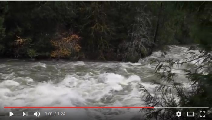
This video from Alberni Valley News tells the story. It starts in the lower Somass River at the marina and continues upstream to the Hwy#4 Bridge, then to Stamp Falls which is mid river. Note the last section is the Stamp Falls section and you will notice there are no falls! The river is that big.
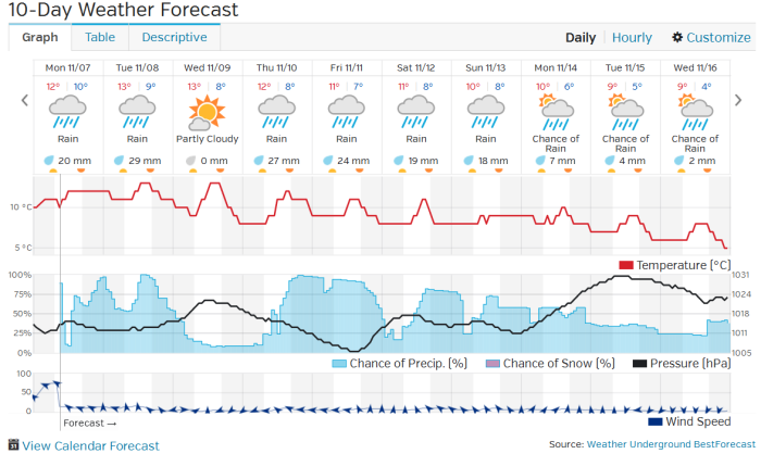
We had a breather for a couple of days with very little rain to get some of the excess out but now there is another rain warning and hurricane force winds.
This weeks highest tides are relatively small which is a god send, because if we had this river level and twelve foot tides the entire Somass area would have had devastating flooding. We hope the waters recede before the weekends big tides (12 foot plus). When the river is this high the tidal influence of the ocean has a large impact as the river gets backed up pushing against the incoming tide. The influence can go for a few miles upstream of paper mill dam.
River Guages
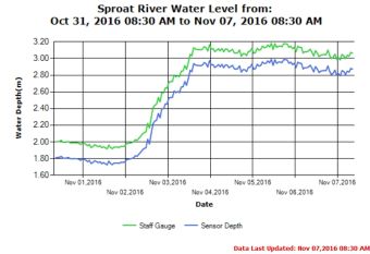
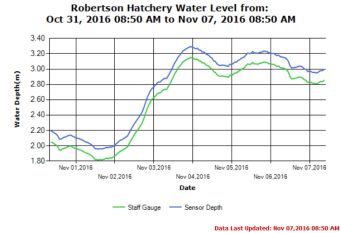
DFO has a series of gauges on the river which we utilize to share information on levels. The equipment at Stamp Falls have been removed to prevent damage caused by the river force. So for an indicator we are looking at Robertson Creek Hatchery which is on the very upper Stamp River. This will be the first to drop since its near the headwaters. It is not a good indicator of what is going on down stream below all the other in flowing tributaries. This area is the first to drop.The other functioning gauge is the Sproat River. In high water conditions this is very helpful towards indicating the trend but it is a very short river with Sproat lake behind it.
Environment Canada is considering putting in an independent system on the upper Somass but we haven't seen it materialize yet. This will be very helpful for flood warning and a bonus to anglers!
As you can see by the trend since Nov 1, the risk we are at of major widespread flooding with the next storm. Even with the brief two days of low rainfall the Sproat barely budged and the Upper Stamp dropped a little. We were already in high water conditions prior to Nov 1st! (anything above 1.5 for Sproat is high)
 |
 |
Weekly Weather Outlook
Our services are now on the "Winter Program" which mean day charters are available with our without accommodations. We do provide accommodations for those who require them with a full breakfast and boxed lunches.
Available Dates:
| Date | Availability |
| Nov 2 Wednesday | Cancelled High Water |
| Nov 3 Thursday | Cancelled High Water |
| Nov 4 Friday | Cancelled High Water |
| Nov 5 Saturday | Cancelled High Water |
| Nov 6 Sunday | Cancelled High Water |
| Nov 7 Monday | Cancelled High Water |
| Nov 8 Tuesday | Cancelled High Water |
| Nov 9 Wednesday | guides on vacation |
| Nov 10 Thursday | guides on vacation |
| Nov 11 Friday | guides on vacation |
| Nov 12 Saturday | 2 boats available |
| Nov 13 Sunday | 2 boats available |
| Nov 14 Monday | 2 boats available |
| Nov 15 Tuesday | 2 boats available |
| Nov 16 Wednesday | 2 boats available |
| Nov 17 Thursday | 2 boats available |
| Nov 18 Friday | 2 boats available |
| Nov 19 Saturday | Booked |
| Nov 20 Sunday | 2 boats available |
| Nov 21 Monday | 2 boats available |
| Nov 22 to Dec | call for availability |
David and Marilyn Murphy (brother and sister team)
Call anytime for the latest conditions and reports
250-723-8022
murphy@island.net
Professional Contributor to:
Fishtactics ~ Alberta Outdoorsmen Forum ~ Fishing with Rod ~ BC Outdoors Magazine